Related Tours
Altai Tavan Bogd Mountain is a part of Altai Tavan Bogd National Park and is a dream travel destination for trekkers, mountaineers, wildlife lovers, and nature lovers. Not only nature, but the surrounding area is also home to various ethnic groups and historical sites. The highest peak of the mountain is snowcapped Khuiten Peak (4374 m), the highest point of Mongolia. The main habitats of the mountain are Argali wild sheep, Ibex, and snow leopard.
Altai Tavan Bogd Mountain is located in Bayan-Ulgii province on the western frontier of Mongolia borders with China and Russia. 1920 km from Ulaanbaatar and 270 km from Ulgii, a central town of Bayan-Ulgii province. The best way to travel to Altai Tavan Bogd Mountain is overland drive seeing amazingly beautiful sights and natural formations along the way. Or do you have a short of time or make your tour less adventurous? Then take a return or a halfway domestic flight to Ulgii town. Afterward, drive 560 km (on the two ways) on the rough roads between Ulgii town and Altai Tavan Bogd Mountain.
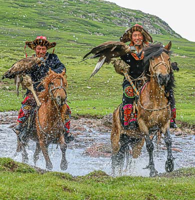
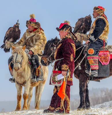
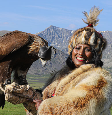
To meet the eagle hunters and for the eagle experiences, travel to Bayan-Ulgii province, the remote western corner of vast open Mongolia where the Kazakhs reside. Not all Kazakhs of Mongolia are eagle hunters. There are approximately 400 registered Eagle hunters due to the Mongolian Eagle Hunters’ Association. The average age of the eagle hunters is 30 to 70 years while the oldest of them is 88 years. It is not unusual to see small boys handling their fathers’ eagles at the age of 6 and 7. Eagle hunting is not the work of a man. There are 11 eagle huntresses. One of them is a 13-year-old teenage huntress Ashlopan who competed against the adult hunters in the 2014 Eagle Festival and won prizes.
Eej Khairkhan Mountain is a part of 22.475 hectares of Eej Khairkhan Nature Reserve since 1992, designated to protect the local environment of the Gobi desert area. The Eej Khaikhan Mountain locates on the territory of Tsogt Soum, Gobi Altai province. 150 km (directly) and 250 km by road in the south of provincial center Altai town and 1120 km from Ulaanbaatar. It is a single granite stone mountain abruptly rising on the sand and gravel plains between Mongol Altai and Gobi Altai Mountains. The mountain’s location on the migrating route of the wild creatures allows some lucky travelers to see the Argali, Ibex, and snow leopard. The eroded granite rocks form many spectacular shaped rock formations. It is fun to walk in the mountains seeing the rock formations. The mountain name Eej Kharkhan means “Mother Mountain” due to its overall shape and historical evidence. The mountain has been worshipped by Mongolians.
Gurban Tsenkher is a limestone cave located 25 km west of Mankhan soum, Khovd province 1340 km southwest of Ulaanbaatar at an altitude of 1571 m above the sea level. The cave is named differently. Both Gurban Tsenkher Cave and Khoid Tsenker Cave are for the same cave. Tsenkher is the name of a nearby river and there are 3 Tsenkher rivers: North Tsenkher, Middle Tsenkher, and South Tsenkher. The cave is closest to North Tsenkher or Khoid Tsenkher.
Location: The Kharkhiraa and Turgen Mountains tower Uvs and Khovd province territory 1500 km to the west of Ulaanbaatar. The nearest town Tarialan 11 km, nearest provincial center Ulaangom 30 km and the nearest accommodation ger camp 40 km. Adventure travelers can stay with the nomadic families and camp in the mountains.
Kharkhiraa and Turgen are two mountains divided by Kharkhiraa passage and a part of Uvs Nuur strictly protected area. The mountain peaks are two snow-capped twin towers: Kharkhiraa Mountain peak is 4037 m Most Uul and Turgen Mountain peak is 3965 m Deglii Tsagaan.
Location: 90 km from Ulgii town and 110 km from Altai Tavan Bogd Mountain in Tsengel soum, Bayan-Ulgii province in western Mongolia. The lakes are part of Altai Tavan Bogd National Park within the country's border zone. Therefore, border control permission is required before traveling the lakes. The permission is available at the Border Patrol in Ulgii.
The picturesque twin Lake Khoton and Khurgan are the freshest water lakes in Mongolia and interconnected by 2 km channels to each other.
Location: 110 km from Ulaangom, a central town of Uvs province, 30 km from Zavkhan soum, and 1300 km from Ulaanbaatar at an altitude of 1035 m above the sea level.
Khyargas is a saltwater lake amidst semi-desert in the Great Lakes Depression/Ikh Nuuruudiin Khotgor on the territory of Naranbulag, Tsagaan Khairkhan, Malchin, and Khyargas soum of Uvs province. The lake and its surrounding 332.800 ha protected area were established as a nature reserve in 2000. The lake is 75 km long, 31 km wide with a surface area of 1481 км². The average depth is 50 m and 80 m at its deepest. The lake is a magnet for migratory birds including its island. The lake’s main attraction is Khetsuu Khad rock on the eastern shore of the lake. Khetsuu Khad is a 5-7 km long underwater rock. Some parts of the rock sticks out of the water, look like islands where countless migratory cormorant birds attracted and nest. Khetsuu Khad rock is a favorite spot for photographers and local travelers.
Location: 40 km south of Khovd town of Khovd province and 1390 km west of Ulaanbaatar.
Khar Us Lake is the second large freshwater Lake in Mongolia after Khuvsgul Lake. Elevated 1156 m above the sea level, 72 km by 36 km in size. The lake is relatively shallow with an average depth of 2.2 m and a maximum depth of 4.5 m. Lake has 10 islands. Khar Us lake is divided into north and south by Agshab, 30 km long and 274 sq kilometers reed-covered island. Overall, the lake and its reed-covered shallow wetland area are a perfect habitat for waterfowls by Ramsar Convention and a paradise for the bird watcher. There are about 200 species of birds registered and about 20 species are rare or endangered: Dalmatian pelican, white-headed duck, swan-goose, Pallas’s fish eagle, greater spotted eagle, black stork, lesser kestrel, white-naped crane, great bustard, white spoonbill, great crested grebe, and relict gulls.
Mongolian largest sand dune Mongol Els stretches 300 km on the territory of Aldarkhan soum in Zavkhan province, Jargalant, Bayan-Uul, and Khukh Morit soum in Gobi Altai province. The sand dunes edge with 800 km Zavkhan River on its northern edge. There are several picturesque lakes along the long sand dunes such as Ereen Lake, Ajig Lake, Sangiin Dalai Lake, and Gun Lake. 349200-hectare area of Mongol Els was protected as a nature reserve since 2010 to keep its natural balance, protect its flora, and fauna.
Location: 1200 km from Ulaanbaatar and 45 km northeast of Erdenekhairkhan soum of Zavkhan province in western Mongolia.
Mukhart River sources out of Bor Khyariin Els/Bor Kyar sandune towers 450 m above the surrounding plain. The river creates several beautiful oases lined with berry trees, willow trees, gentian, and caraway. The picturesque area is one of the famous attractions of Zavkhan province when traveling to western Mongolia.
Seeps out of Bor Khyar sanddunes , Mukhart River is located in Zavkhan province in western Mongolia. The river is lined by berry trees and creates beautiful oasis.
Location: 1200 km from Ulaanbaatar and 65 km from Otgon soum of Zavkhan province. The distance to the provincial center Uliastai town is 100 km.
Snowcapped Otgontenger Mountain is the highest peak of Khangai Nuruu Mountain Range in central Mongolia and a part of Otgon Tenger Strictly Protected Area protects rare plants and animals such as roe deer, Siberian musk deer, Saussurea dorogostaiskii Palib, and Argali wild sheep. Most recent surveyors agreed the peak of the mountain is 4008 while most topographical maps show 4021 m.
Location: 1130 km west of Ulaanbaatar, 95 km north of Uliastai town in the Erdenekhairkhan soum of Zavkhan province.
The rock formations of Senjit Khad or Senjit Rock towers on the top of a mountain among the Gobi desert and mountainous steppes. The Senjit Khad is a 1 km long rock with a 6 m wide and 3.5 m tall arch, formed by the Gobi desert wind.
Location: 1210 km from Ulaanbaatar, 200 km from Gobi Altai province central town Altai and 230 km from Khovd, a central town of Khovd province. The mountain will be seen from the Altai and Khovd town main road.
Sutai Khairkhan Mountain peak is 4220 m (13.845 ft) Tsast Bogd/Tsast Uul, one of the 13 snow-capped peaks of the Gobi Altai Mountain Range. The Sutai Khairkhain Mountain stretches 60 km on the territory of Tonkhil soum of Gobi Altai province, Darvi and Tsetseg soums of Khovd province.
Location: 1380 from Ulaanbaatar and 80 km north of Khovd, a central town in Khovd province in western Mongolia along the Khovd and Ulgii town roads.
The researchers set up some snow and glacier measuring tools that help to study the global warmth showing the same indication as the northern pole.
Altai Mountain Range branch Tambagarav Mountain is a part of Tsambagarav National Park. The 110,960 ha area was set up in 2000 to protect endangered species such as Snow Leopard, Argali sheep, Ibex, Rock Ptarmigan, and Altai Snowcock. The Argali wild sheep found in the park is the largest in the world.
Location: 120 km from Ulgi town of Bayan-Ulgii province
There are several waterfalls among the outstanding nature of the Turgen Mountains in western Mongolia. One of them is Baga Turgen waterfall in Turgen gorge near the western shore of the picturesque Khoton and Khurgan Lakes. The glacier waterfall falls from 36 m cliff and divided into two waterfalls. The bigger waterfall heights 23 m while the smaller one falls from 13 m. The pristine Turgen valley is an ideal place for hiking and has some historical relicts.
Location: 1160 km from Ulaanbaatar, 80 km from Erdene Khairkhan soum and 110 from Uliastai, a central town of Zavkhan province
Ulaagchiin Khar Lake is a beautiful lake in the semi-desert area. The northern shore of the lake is lined with impressive sand dunes and its southern reed shore and islands are magnet for migratory waterfowls. The lake is 30 km long, 10 km wide and 48 m deep. Nearby mountains are home to rare wild habitats including snow-leopard.
Location: 90 km from Altai Soum, Bayan-Ulgii province in western Mongolia and 200 km from the provincial center Ulgii Town.
Yolt basin is a part of the Altai Tavan Bogd National Park and located along the country’s western frontier where Mongolia borders with China. The forested and untouched Yolt Valley is home to some rare species such as snow leopard, wild sheep Argai, Ibex, and brown bear. This mountainous area is relatively cool compared to the other parts of Mongolia and is extremely rich in medicinal plants. It is the least traveled horse riding and trekking destination in Mongolia.
Location: 1460 km from Ulaanbaatar, 36 km from Ulaangom, a central town of Uvs province in the northwestern part of Mongolia.
The saline lake Uvs is the largest lake in Mongolia covers 3350 sq.kilometer surface area. A small part of the lake sticks into Russia. Uvs is a 10-20 m deep relatively shallow lake with a width of 79 km and a length of 84 km.
679600-hectare area of Uvs Lake basin comprises of alpine mountains, snow-capped mountains, steppes, several smaller lakes, semi-desert including 180 long Altan and Buurug Del sand dunes. The basin was set as a strictly protected area to protect its flora, fauna, distinctive natural formations, and historical site. Uvs Lake basin is a Central Asian largest untouched Inland watershed. About Uvs lake, 38 rivers feed the lake such as Baruunturuun River, Nariin River, Kharkhiraa River, and Sangil River from the Altai Mountains.